RESEARCH


Autonomous Drone-Based Framework for Safe and Efficient Rooftop Gutter Maintenance

Rooftop gutters are highly vulnerable to debris accumulation, creating safety hazards for buildings. Conventional cleaning methods relying on ladders or ropes remain inefficient and unsafe, making them unsuitable for modern maintenance. This project explores an autonomous drone-based framework capable of precise navigation, real-time obstacle avoidance, and multi-stage mission execution. The system prepares for continuous rooftop scanning and debris data collection, offering a safe, scalable, and efficient solution for high-altitude building maintenance.


Learn More

AI-Driven Time Series Analysis in Smart Healthcare Monitoring

As populations age, hospitals and long-term care facilities face growing fall risks and staffing pressures, while families supporting aging-in-place need unobtrusive ways to recognize meaningful changes in daily routines. We transform everyday sensor data into early, trustworthy insights: using bed sensors with time-series models, we predict bed-exit intention minutes in advance to help prevent unassisted falls; combining smart-home sensors with large language models (LLM), we detect routine anomalies and generate trend narratives that highlight when patterns deviate. The goal is to support safer hospitals and aging-in-place by providing clinicians and caregivers with timely, interpretable alerts that improve response time and reduce workload.


Learn More

Fusion of Multi-modal Inspection Data for Pipeline Integrity Management

Accurate detection and characterization of defects through in-line inspection is essential for ensuring the safety of oil and gas pipelines. However, individual inspection modalities face inherent limitations. For example, Magnetic Flux Leakage often struggles with axial defects, while Ultrasonic Wall Measurement suffers from relatively low spatial resolution. A single inspection modality cannot provide a comprehensive assessment of all defect types. In this research project, we aim to develop the data analytic and data integration capabilities for multi-modal in-line inspection of gas and oil pipelines with machine learning techniques.


Learn More

Knowledge Distillation Enhanced Prompt Learning for Remote Sensing

Recent vision–language models (e.g., CLIP) excel at self-supervised vision learning, but adapting them to aerial imaging is difficult due to suffer from limited annotated datasets, unintuitive image contrasts, and nuanced visual features. In this research project, we address this with prompt-context learning that averages LLM-generated prompts for semantic consistency and distills knowledge based on a statistics-based prompt selector. The result is a lightweight, efficient, easily fine-tunable model that performs strongly on aerial imagery across zero-/few-shot, base-to-novel, and retrieval tasks.


Learn More

Integrating Optical and RADARSAT-2 Imagery for Enhanced Lake Ice Monitoring

This research focuses on developing a novel approach for enhancing Canadian lake ice monitoring by integrating multi-sensor satellite imagery. The methodology addresses the inherent limitations of relying on a single data source by combining optical imagery with Synthetic Aperture Radar (SAR) data from RADARSAT-2. Although optical imagery provides high-resolution and visually intuitive information, its effectiveness is constrained by persistent cloud cover and the lack of sunlight during northern winters. In contrast, RADARSAT-2 can penetrate clouds and collect data independent of solar illumination, but its backscatter signals are more challenging to interpret for ice type and thickness.
To overcome these challenges, this study proposes a data fusion framework that combines the all-weather capability of RADARSAT-2 with the detailed surface information from optical sensors. The integrated dataset will support the training and validation of machine learning models to classify key lake ice characteristics, including freeze-up, break-up, and thickness. The outcome will be a more consistent and reliable method for monitoring ice conditions, directly informing decisions on the safe opening and closing of winter roads in Canada’s remote northern regions. Ultimately, the system will function as a robust decision-support tool, improving transportation safety for communities that depend on these critical ice corridors.


Learn More

Continual Learning for Maritime Object Detection

Traditional object detection systems require retraining from scratch whenever new data or categories are introduced. This is inefficient and often leads to catastrophic forgetting, where the model loses performance on previously learned tasks. Continual learning addresses this challenge by enabling models to adapt incrementally, learning new objects without losing knowledge of existing ones. This is especially important in the maritime domain, where vessels come in diverse types and new categories may appear over time.
In this project, we focus on developing continual learning methods for maritime object detection, aiming to detect and recognize different types of ships while retaining accuracy across previously learned classes. Our goal is to make these systems more robust, adaptable, and practical for long-term use at sea.


Learn More

Remote Sensing Data Analysis for Infrastructure Deformation Assessment

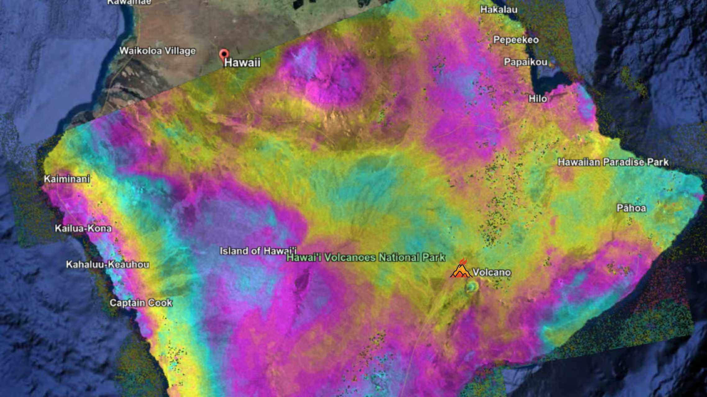
The infrastructure network of North America is a critical component of its economic and societal framework, yet much of it is aging and requires systematic assessment. A significant portion of this infrastructure, including roads, railways, and buildings, was constructed in the 20th century, exceeding their typical rated useful life of 20 to 25 years. As these assets age, their structural integrity deteriorates, increasing the risk of deformation and failure during routine operations or extreme events. This highlights the necessity of effective maintenance strategies to ensure safety, functionality, and resilience. Non destructive testing techniques to evaluate structural integrity are widely used in civil engineering, including on site inspections and drone based monitoring. However, these methods are limited in spatial coverage, primarily capturing small and localized areas. To address these limitations, remote sensing technologies provide extensive spatial coverage and enable millimeter level deformation monitoring, facilitating comprehensive evaluations of infrastructure stability. This project aims to utilize advanced remote sensing to monitor infrastructure deformation and predict potential failures by integrating environmental factors.


Learn More

Thermal Image Translation for Enhanced Environmental Perception at Night

Human have poor night vision compared to many animals, partly because human eyes lack tapetum lucidum. This biological deficiency may lead to several undesirable fatalities. Hence, context enhancement plays a critical role in many night vision applications. In the dark night situation, the visible camera doesnot function properly but the Infrared (IR) themal camera works well which can highlight the objects with emitted energy. Theoretically, the useful semantic information of an image to the human visual system (HVS) includes contour, texture and color. But the IR image only has the contour information. In this research project, we aims to develop a framework to translate the IR image at dark night to the colorful visible image with rich semantic information for enhanced environmental perception at night.


Learn More

Deep Multi-modal Image Fusion for Enhanced Situation Awareness

Automated situation awareness in the complex and dynamic environments is a challenging task. The accurate perception of the target is critical for the successful completion of a mission. In this research project, the objective is to develop a deep learning multi-modal image fusion algorithm for enhanced situation awareness and toward the preservation of soldier safety in operations, the achievement of threat identification and possible avoidance, the minimization of collateral damages, and the achievement of improved speed, accuracy, confidence, assurance, and precision of impact as part of the operations decision-action cycle.


Learn More

Deep Learning for Applications in Property Assessment

Property assessment is the procedure of valuation of estates which is important in terms of daily life and urban planning. Current relevant methods are commonly based on pure house own attributes. However, the values of houses also depend on various factors of community, geography, and appearance. We aim to take advantage of deep learning approaches from RNN to CNN to incorporate such factors for property assessment.


Learn More

Ais Data Driven Vessel Destination Prediction

Navigation is one of the majority transportation in the world. However, the accurate destination prediction for on-the-way vessel is not available now. Through analysing the historical AIS records and geographical information, we proposed a machine learning based vessel destination prediction through comparing on-the-way trajectory with historical trajectories approach.


Learn More

Data-driven Predictive Analytics for Infrastructure Management

Canadian municipalities have reported that 59% of the water systems needed repair and the status of 43% of these systems is unacceptable. Thus, it is important to have an integrated asset management system to optimize the rehabilitation process. The integrated infrastructure management consists of several components such as asset condition monitor and evaluation, pipe failure consequence, and risk analysis. The objective of our study is to provide an integrated decision-support framework for asset management by developing a general ensemble learning framework for pipe performance prediction and a weighted-score system for pipe risk analysis.


Learn More

Oil and Gas Pipeline Integrity Assessment Based on ILI Data

Oil and gas pipelines are subject to catastrophic accidents or failures due to leakages and ruptures. Wall thickness loss due to corrosion is a significant reason for pipeline failure. Therefore, In-line inspection (ILI) is carried out periodically to detect and quantify the metal loss. Multiple sensors are often employed to perform the non-destructive in-line inspection. In this research project, we aim to fuse multiple ILI data, e.g. magnetic flux leakage (MFL) and axial flaw detection (AFD) data, to achieve improved pipeline integrity assessment.


Learn More

Automated Measurement of the Joint Gap in Pipeline

CCTV (closed-circuit television) inspection system is well adopted for water pipe inspection. Modern CCTV system is equipped with high-definition camera, laser profiler, and sonar sensor for a more comprehensive assessment of pipe condition. Automatic and quantitative interpretation of the inspection data still remains as a technical gap for current CCTV systems. As laser profiling is precise, it is possible to achieve an accurate measurement with the laser sensor. One practical need is to quantify the joint gap between pipe segments. The objective of this research project is to develop algorithms to extract projected laser profile on pipe inner surface from CCTV video sequences and measure the gap with required precision.


Learn More